In this guide, we will show you the steps to measure the distance between two or more points in Google Maps. There are quite a few applications that are available for navigation purposes. However, none comes close to what Silicon Valley giants aka Google have to offer. Not only is it pin-point accurate most of the time, but its also quite feature-rich in itself.
Some of its features like searching for the location, changing the preferred mode of transport or saving your favorite locations is something that many of you might very well be aware of. However, the ability to measure the distance between two locations is something that not many of you might be aware of.
Therefore, today we will be highlighting just that. The tutorial to measure distance in Google Maps between two or more places will furthermore be divided into three sections, for each of the platforms, i.e PC, Android, and iOS. So without further ado, let us begin with the instructions. On that note, also check out our guide on how to enable Google Maps Incognito Mode on smartphones.
Also Read
Page Contents
How to Measure Distance in Google Maps using PC
- On your desktop, head over to the Google Maps website.
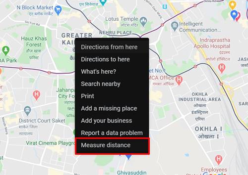
- Choose your starting point and right-click on it. Then from the menu that appears, click on Measure Distance.
- Next up, click on the second location in the Google Maps up to which you wish to calculate the distance.
- Maps will then display the total distance between these places right at the bottom. The distance will be displayed both in miles and kilometers.
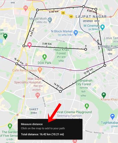
- That’s not all. You could extend it to other places as well. Just click on the next preferred location and Maps will subsequently show the updated distance. You could add as many stops as you wish on the maps and calculate the distance.
So this is how you could measure the distance between two or more points in Google Maps on your PC. Let us now check the steps to do so in Android and iOS, beginning with the former. On the other hand, if you are having trouble with Google Maps Voice Navigation, check out our detailed guide on how to fix it.
Also Read: How to Use Waze or Google Maps Offline to Save Internet Data
Measure Distance in Google Maps on Android
- Launch the Google Maps app on your Android smartphone.
[googleplay url=”https://play.google.com/store/apps/details?id=com.google.android.apps.maps&hl=en_IN”] - Set up the starting point on the map by long-pressing at the desired location. You should then see a red pin at that location.
- Next, tap the name of that location in the bottom bar to bring up a menu. Select the Measure Distance option from the list.
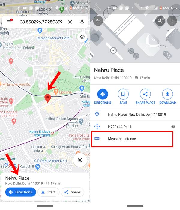
- Now tap on the second location of which the distance needs to be calculated and tap on the Plus icon situated at the bottom right. In doing so, Google Maps will display the total distance between these two points.
- Likewise, you could add many such locations. Just tap on the desired place on the map and tap on the Add point icon. Google Maps will measure the total distance and display the same. The distance will be shown at the bottom of your screen, in miles.
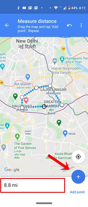
- If you wish to remove the last stop, take the help of the Undo option situated at the top bar. To remove all the stops, tap the overflow icon and select Clear.
Measure distance in Google Maps on iOS
To measure distance in Google Maps between two or more places on your iPhone & iPad, follow the below steps.
- Open the Google Map app on your iOS device.
- Tap anywhere on the map to set up the first location. At that point, you will now see a red pin.
- In the bottom bar, the name of that place should be visible. tap on it and select the Measure Distance option from the menu.
- Next up, scroll the map and add mark your second point on it. The same could be done just by tapping in that place. Google Maps will then measure the distance and display the same on your screen at the bottom.
- To add more points or stops, just tap on the Add Point icon. You could as many points as you need. Maps will calculate the total distance from each point and will display the same.
- To remove the last stop, you could tap on the Undo icon situated at the top right. To clear all the points, tap on the overflow icon and select Clear.
These were the required steps to measure the distance of two or more places via Google Maps. We have listed the instructions for all three platforms, PC, Android, and iOS. However, if you still face any issues, drop in your queries in the comments section below. Also check our all iPhone Tips and Tricks, PC tips and tricks and Android Tips and Tricks section to gather more knowledge.
